Showing posts with label cartography. Show all posts

31 July 2019

Why maps have north at the top

One perennially popular question on ask-an-expert social media is: why do maps have north at the top? Is there a solid reason for it, or is it arbitrary?

The answer, just to give you a heads-up, lies in Greco-Roman antiquity.

Now, you will often see maps rotated to arrange a region or a building in a tidy rectangular space. A GPS service may turn a map continuously so that ‘up’ is always the direction you’re facing. Those things are fine. But if you open up a printed roadmap, or an atlas, you don’t want to hunt around to find out which direction is which. If you open up Google Earth, there’s a prominent button that will turn the map so that north is at the top.

We can grant that the four cardinal directions -- north, east, south, and west -- aren’t arbitrary. They’re determined by the geometry and rotation of the Earth. But you still need to choose which of those four to put at the top. The four cardinal directions aren’t arbitrary, but which of the four you choose -- that is arbitrary.
The central Mediterranean in four orientations. Each of these is a perfectly reasonable, non-arbitrary way of orienting a map. The arbitrariness comes in which of the four you choose.
(Actually there are eight possibilities, if we also admit the possibility of maps drawn from an underground perspective. We’ll assume we’re not doing that. We’re also ignoring maps with polar geometry, that is, with the south pole or north pole at the centre.)

Map-makers of various periods and places have certainly chosen directions other than north to put at the top. Prior to the 1400s there was no consistency. The Moroccan cartographer Muhammad al-Idrisi drew up a map in 1154 of western Asia, northern Africa, and Europe, with south at the top. Mediaeval T-and-O maps, like the Hereford mappa mundi (ca. 1300), have east at the top. Albertinus de Virga’s world map (ca. 1415) has north at the top, Fra Mauro’s (ca. 1450) opts for south. None of these options is intrinsically better or worse than the others.

Top: Muhammad al-Idrisi’s map, with Asia at the left, northern Africa at the top, and Europe at the bottom right. Bottom: the Hereford mappa mundi along with a stylised simplification.
Anyway, the obvious question is: why? Why did European mapmakers switch to having north at the top so consistently in the late 1400s?

If you do make the mistake of asking this on an ask-the-experts forum, you will get completely speculative answers:
  • ‘Europeans wanted to put Europe at the top ... [so] their maps would end up having the largest sway’. (That’s a good post hoc rationalisation for keeping maps pointing that way, but it isn’t the historical cause.)
  • Globes supposedly are naturally arranged with the axis of rotation pointing vertically (why?), and ‘globes have existed ... since the third century BC’. (They haven’t: this sub-myth comes from a mistranslation of Strabo.)
  • Compass needles supposedly point up. (Funny, I thought they’re horizontal.)
  • Alternatively, ‘you rotate [your map] until the needle is pointing away from you’. (Actually, 15th century European compasses pointed south.)
  • ‘[S]tars apparently rotate around the north pole’, and somehow that translates to having a map arranged with the ‘up’ side away from the reader.
  • There’s more land in the northern hemisphere, and somehow that makes north naturally ‘up’. (This answer comes closest to the reality, but still not close enough.)
Now, it’s imaginable that any of these speculations may hold true for some particular time, some particular place, some particular mapmaker. None of them comes close to the historical cause, though.

The short answer is that it was in the late 1400s that Ptolemy’s Geography became widely available in printed editions. Ptolemy, forgotten since antiquity, suddenly became insanely influential. And Ptolemy put north at the top.

(That wasn’t a universal thing in antiquity, either, by the way: Ptolemy makes a careful argument for his choice. We don’t know which way the maps of Eratosthenes or Marinus of Tyre were oriented.)

Ptolemy’s map, designed in the 2nd century, may look a bit shonky to modern eyes -- India and China are badly misshapen, most of Africa is missing, Scotland is completely misplotted. But for the Mediterranean world Ptolemy’s latitude and longitude data, based on Roman survey work, are pretty accurate, and very convenient. As a result, renaissance-era European mapmakers followed both his data -- until explorers improved on it -- and his design choice about which way north is.
Table 1 from the 1477 Bologna edition of Ptolemy’s Geography. The projection used to represent the curved surface of the earth isn’t rectilinear, unlike the maps of Marinus of Tyre and Mercator. This is the first projection Ptolemy outlines in his theoretical introduction (Geog. 1.24); many renditions of Ptolemy’s data use the second projection instead.
In 1406 Jacopo d’Angeli translated the Geography into Latin, from the Greek text assembled by Maximus Planudes. After the advent of the printing press, the translation appeared in several print editions -- four in a space of seven years: first the 1475 Vicenza edition, with just the raw data; then with the data plotted onto maps in accordance with Ptolemy’s directions, in the 1477 Bologna edition, the 1478 Rome edition, and the 1482 Ulm edition. Reprints followed quickly. Ptolemy was hot stuff.

One exception, by the way, is Fra Mauro’s map, made around 1450. Fra Mauro had access to data from further afield, about southern Africa and eastern Asia, but he still draws on Ptolemy for some things like the enormous island of Taprobana (far larger than Sumatra or Sri Lanka, the two islands that Ptolemy’s defenders try to identify it with). Fra Mauro doesn’t follow Ptolemy’s choice about orientation, though. Bear in mind that Fra Mauro lived before the spate of Ptolemy editions in the 1470s and 1480s.

You will occasionally find that an online ‘expert’ is aware of Ptolemy as the real reason. But even then, they’ll be blissfully unaware of why Ptolemy made that choice. Ptolemy explains, directly and explicitly, why he puts north at the top. And though his reasoning is arbitrary to an extent, it’s also data-driven.

It’s probably worth taking note, for a start, that Ptolemy was neither European nor a Roman citizen, and that because of axial precession, the North Star was several degrees away from the pole in the 2nd century when Ptolemy was alive. So a lot of the usual speculative reasons don’t apply (it’s all eurocentrism, or European colonialism, or the North Star is ‘up’). That said, here’s his explanation in his own words:
We have selected the arrangement for convenience of design, taking everything into consideration. It is based on the principle that we move to the right, with transitions from things that are already set down, to those that are not yet taken in hand. This will be the case if northern parts are drawn before southern parts, and western parts before eastern parts. So, to those designing or viewing the map, the north lies up, and the east of the world lies to the right, on both the globe and the map. Therefore we shall begin with Europe and divide it up; then we move to Africa via the Strait of Herakles; then to Asia, after covering the sea in between ...
-- Ptolemy, Geography book 2, prologue, §§4-6
In other words, maps have north at the top because ancient Greek was written left-to-right and top-to-bottom.

Ptolemy’s sudden popularity in the late 1400s has positive and negative sides to it. It certainly fed Columbus’ misapprehensions about the size of the earth. You might feel that the impact on map orientation is a good thing, because a universal standard is good, or a bad thing, because there’s no very good reason to have maps as standardised as all that.

There’s no doubt that map orientation has fed colonialist impressions about which bits of the world are important and which ones aren’t. That’s one thing that you will regularly see pointed out in response to this question -- thanks to a memorable episode of the TV series The West Wing.
Dr Fallow. When third-world countries are misrepresented, they’re likely to be valued less. When Mercator maps exaggerate the importance of western civilization, when the top of the map is given to the northern hemisphere, and the bottom is given to the southern, then people will tend to adopt ‘top’ and ‘bottom’ attitudes.
C.J. But ... wait, h- -- where else could you put the northern hemisphere but on the top?
Dr Sales. On the bottom.
C.J. How?
Dr Fallow. Like this.
C.J. Yeah, but you can’t do that.
Dr Fallow. Why not?
C.J. ’Cause it’s freakin’ me out.

20 November 2018

Cosmos #1. Eratosthenes

Carl Sagan’s TV series Cosmos has had an enduring effect on people’s perceptions of antiquity. Most of those perceptions are only half-true.


There is some genuine factual material in Cosmos, but it’s pretty evenly blended with fiction. Sometimes that’s for the sake of making a good story. But often it comes from relying on sources who were lazy, who knew little about their subject, or who were heavily biased.

For those who like to challenge popular misconceptions, it can be a little laborious to work out exactly which misconceptions come from Cosmos. So, here and in the next two posts, I’ll give a transcript of the segments that deal with ancient Greek science, with a few selected annotations.

I’ve found that many people don’t appreciate just how much of an impact Cosmos has had in the 38 years since it was first broadcast. Let me illustrate.

In 2009 the film Agora, directed and written by Alejandro Amenábar, perpetuated the myth that Hypatia’s death was linked to the catastrophic destruction of the famous libraries of Alexandria. There’s no reason to imagine any link between these two events (and little reason to believe that the second actually happened). Guess who invented the link?

In 2016 a prominent website published a video on Eratosthenes’ measurement of the earth’s circumference. Guess who the video cited as its sole historical source? This video got 24 million views when it was posted on Facebook. Half of it was false. And every one of the falsehoods was repeated from Cosmos.

Business Insider video on Eratosthenes’ measurement of the earth, July 2016: final shot (left) and the entire credits sequence (right).

In 2017 an article in The Guardian pulled the same trick. Once again, it’s only half true. Once again, the author got all his history directly from Cosmos.

Cosmos is getting a bit long in the tooth, but the entire series is on YouTube; it had a revival in 2014; another series is scheduled for 2019. Its influence lives on. So, for those who want to know what stories Sagan spread, but who don’t want to have to spend thirteen hours watching the whole thing, here are the relevant bits, in three parts. Today: Eratosthenes.


Episode 1. ‘The shores of the cosmic ocean’

YouTube link. First broadcast 28 September 1980.

Carl Sagan:
There was once a time when our little planet seemed immense, when it was the only world we could explore. Its true size was first worked out in a simple and ingenious way by a man who lived here in Egypt, in the third century BC.

This tower may have been a communications tower, part of a network running along the North African coast, by which signal bonfires were used to communicate messages of state. It also may have been used as a lighthouse, a navigational beacon for sailing ships out there in the Mediterranean Sea. It is about 50 kilometers west of what was once one of the great cities of the world, Alexandria.

In Alexandria, at that time there lived a man named Eratosthenes. One of his envious contemporaries called him ‘Beta’, the second letter of the Greek alphabet because, he said, Eratosthenes was second best in the world in everything. But it seems clear that in many fields, Eratosthenes was Alpha. He was an astronomer, historian, geographer, philosopher, poet, theater critic, and mathematician. He was also the chief librarian of the great library of Alexandria. And one day, while reading a papyrus book in the library, he came upon a curious account.

Far to the south, he read, at the frontier outpost of Syene, something notable could be seen on the longest day of the year. On June 21st the shadows of a temple column or a vertical stick would grow shorter as noon approached. And as the hours crept towards midday, the sun’s rays would slither down the sides of a deep well, which on other days would remain in shadow. And then, precisely at noon, columns would cast no shadows, and the sun would shine directly down into the water of the well. At that moment the sun was exactly overhead.

It was an observation that someone else might easily have ignored. Sticks, shadows, reflections in wells, the position of the sun: simple, everyday matters -- of what possible importance might they be? But Eratosthenes was a scientist and his contemplation of these homely matters changed the world -- in a way, made the world. Because Eratosthenes had the presence of mind to experiment, to actually ask whether, back here, near Alexandria, a stick cast a shadow near noon on June the 21st. And it turns out, sticks do.

Notes: see this older post and this one on Eratosthenes’ measurement of the earth.
  1. Eratosthenes was not discovering secrets in obscure texts, but making use of long-standing public knowledge. The shape of the earth was well-known; measuring latitude with a gnomon was standard practice.
  2. The calculation was based on readings taken at Syene and Meroë, not Alexandria and Syene. Correction, two days later: thanks to Seb, in the comments, for pointing out my error here. According to Martianus Capella, Eratosthenes used readings taken at Syene and Meroë (not Alexandria); according to Cleomedes, at Alexandria and Syene (not Meroë). Cleomedes tends to have greater clout, but there’s absolutely no doubt that Eratosthenes did use readings from Meroë too. He regarded all three sites as being on the same meridian, and equidistant. He may have used one set of readings to corroborate the other.
  3. A well at Syene played no role in the calculation.
  4. Observations were taken at the equinoxes, not the solstice. Correction, two days later: thanks to Seb again. According to Cleomedes, Eratosthenes used observations taken at the solstice; according to Vitruvius, at the equinox. The equinox appears to have been the standard time of year for gnomon readings designed to measure latitude (see e.g. Pliny NH 2.182). Strabo 2.1.20 points out that Philon took gnomon readings at Meroë at both the solstices and equinoxes, and that ‘Eratosthenes agrees very closely with Philon’: it seems simplest to infer that Eratosthenes actually used both. (Equinoctial observations make it trivial to calculate latitude, because at the equinox, and only at the equinox, the sun’s rays are parallel to the plane of the earth’s equator.)
  5. The gnomon readings Eratosthenes used were taken decades before his time, and the overland distance estimates over a millennium earlier.
  6. The distance units definitely did not correspond to 800 km or 40,000 km. They were in the region of 900-960 km and 45,000-48,400 km. Still impressive, but more than ‘a few percent’ off. Eratosthenes improved on estimates reported by Aristotle (ca. 74,000 km) and Archimedes (ca. 55,000 km), but it was not a radical novelty.

An overly skeptical person might have said that the report from Syene was an error. But it’s an absolutely straightforward observation. Why would anyone lie on such a trivial matter? Eratosthenes asked himself how it could be that, at the same moment, a stick in Syene would cast no shadow, and a stick in Alexandria, 800 kilometers to the north, would cast a very definite shadow.

Here is a map of ancient Egypt. I’ve inserted two sticks, or obelisks: one up here in Alexandria, and one down here in Syene. Now, if at a certain moment each stick casts no shadow, no shadow at all, that’s perfectly easy to understand -- provided the earth is flat. If the shadow at Syene is a certain length and the shadow at Alexandria is the same length, that also makes sense on a flat earth. But how could it be, Eratosthenes asked, that at the same instant there was no shadow at Syene, and a very substantial shadow at Alexandria?

The only answer was that the surface of the earth is curved. Not only that, but the greater the curvature, the bigger the difference in the lengths of the shadows. The sun is so far away that its rays are parallel when they reach the earth. Sticks at different angles to the sun’s rays will cast shadows at different lengths. For the observed difference in the shadow lengths, the distance between Alexandria and Syene had to be about 7 degrees along the surface of the earth. By that I mean, if you would imagine these sticks extending all the way down to the center of the earth, they would there intersect at an angle of about 7 degrees. Well, 7 degrees is something like a 50th of the full circumference of the earth, 360 degrees. Eratosthenes knew the distance between Alexandria and Syene. He knew it was 800 kilometers. Why? Because he hired a man to pace out the entire distance so that he could perform the calculation I’m talking about. Now, 800 kilometers times 50 is 40,000 kilometers. So that must be the circumference of the earth, that’s how far it is to go once around the earth.

That’s the right answer. Eratosthenes’ only tools were sticks, eyes, feet, and brains -- plus a zest for experiment. With those tools he correctly deduced the circumference of the earth to high precision, with an error of only a few percent. That’s pretty good figuring for 2,200 years ago.

Then, as now, the Mediterranean was teeming with ships: merchantmen, fishing vessels, naval flotillas. But there were also courageous voyages into the unknown. 400 years before Eratosthenes, Africa was circumnavigated by a Phoenician fleet in the employ of the Egyptian pharaoh Necho. They set sail, probably in boats as frail and open as these, out from the Red Sea, down the east coast of Africa up into the Atlantic and then back through the Mediterranean. That epic journey took three years, about as long as it takes Voyager to journey from earth to Saturn. After Eratosthenes, some may have attempted to circumnavigate the earth. But until the time of Magellan, no one succeeded. What tales of adventure and daring must earlier have been told as sailors and navigators, practical men of the world, gambled their lives on the mathematics of a scientist from ancient Alexandria.

The story of the Phoenician circumnavigation of Africa in ca. 600 BCE is based on a single source, Herodotus 4.42, written ca. 425 BCE. It is not strictly impossible, but it is doubtful. Herodotus did not have direct access to written reports of the expedition, but relied on oral interlocutors. The most thorough geographic account of Africa that we have from the Mediterranean world, that of Ptolemy, has no known southern boundary to Africa. The one point that supports the story, that the sailors reportedly saw the sun in the northern half of the sky, is not necessarily proof: this would be observed in summer anywhere south of the Tropic of Cancer (still within the latitude of Egypt).

Today, Alexandria shows few traces of its ancient glory, of the days when Eratosthenes walked its broad avenues. Over the centuries, waves of conquerors converted its palaces and temples into castles and churches, then into minarets and mosques. The city was chosen to be the capital of his empire by Alexander the Great on a winter’s afternoon in 331 BC. A century later, it had become the greatest city of the world. Each successive civilization has left its mark.

But what now remains of the marvel city of Alexander’s dream? Alexandria is still a thriving marketplace, still a crossroads for the peoples of the Near East. But once, it was radiant with self-confidence, certain of its power.

Can you recapture a vanished epoch from a few broken statues and scraps of ancient manuscripts? In Alexandria there was an immense library and an associated research institute, and in them worked the finest minds in the ancient world. Of that legendary library all that survives is this dank and forgotten cellar. It’s in the library annex, the Serapeum, which was once a temple but was later reconsecrated to knowledge. These few, moldering shelves probably once in a basement storage room are its only physical remains. But this place was once the brain and glory of the greatest city on the planet earth.

If I could travel back into time, this is the place I would visit. The library of Alexandria at its height, 2,000 years ago. Here, in an important sense, began the intellectual adventure which has led us into space. All the knowledge in the ancient world was once within these marble walls. In the great hall, there may have been a mural of Alexander with the crook and flail and ceremonial headdress of the pharaohs of ancient Egypt. This library was a citadel of human consciousness, a beacon on our journey to the stars.

It was the first true research institute in the history of the world. And what did they study? They studied everything, the entire cosmos. ‘Cosmos’ is a Greek word for the order of the universe. In a way it’s the opposite of chaos. It implies a deep interconnectedness of all things, the intricate and subtle way that the universe is put together.

Genius flourished here. In addition to Eratosthenes, there was the astronomer Hipparchus, who mapped the constellations and established the brightness of the stars. And there was Euclid, who brilliantly systematized geometry, who told his king, who was struggling with some difficult problem in mathematics, that there was no royal road to geometry. There was Dionysius of Thrace, the man who defined the parts of speech -- nouns, verbs, and so on -- who did for language in a way what Euclid did for geometry. There was Herophilus, a physiologist who identified the brain rather than the heart as the seat of intelligence. There was Archimedes, the greatest mechanical genius until the time of Leonardo da Vinci. And there was the astronomer Ptolemy, who compiled much of what today is the pseudoscience of astrology. His earth-centered universe held sway for 1,500 years, showing that intellectual brilliance is no guarantee against being dead wrong. And among these great men, there was also a great woman. Her name was Hypatia. She was a mathematician and an astronomer, the last light of the library, whose martyrdom is bound up with the destruction of this place seven centuries after it was founded.

  • Hipparchus did a lot more than Sagan says. He discovered many difficult points about the dynamics of the sun-earth-moon system, the periodicity of eclipses, the relationship between the solar and sidereal years, and much more. He should probably be regarded as the greatest astronomer of antiquity, perhaps alongside Eudoxus.
  • Ptolemy was much more than a superstitious astrologer. His astronomical model was a more effective predictive tool than Copernicus’, and his works on cartography, music theory, and other matters are easily the most influential historical works ever written on those subjects.
  • Archimedes lived in Sicily, not Alexandria.
  • Hypatia was a major mathematician, but her astronomical work was confined to editing the text of Ptolemy’s Almagest. There is little to suggest a connection between her death and the destruction of the Mouseion: Sagan is directly responsible for the myth that a connection exists.

Look at this place. The Greek kings of Egypt who succeeded Alexander regarded advances in science, literature, and medicine as among the treasures of the empire. For centuries they generously supported research and scholarship -- an enlightenment shared by few heads of state, then or now. Off this great hall were ten large research laboratories; there were fountains and colonnades; botanical gardens; and even a zoo with animals from India and sub-Saharan Africa. There were dissecting rooms and an astronomical observatory.

But the treasure of the library consecrated to the god Serapis, built in the city of Alexander, was its collection of books. The organizers of the library combed all the cultures and languages of the world for books. They sent agents abroad to buy up libraries. Commercial ships docking in Alexandria harbor were searched by the police, not for contraband, but for books. The scrolls were borrowed, copied and returned to their owners. Until studied, these scrolls were collected in great stacks called ‘books from the ships’. Accurate numbers are difficult to come by, but it seems that the library contained at its peak nearly one million scrolls.

The papyrus reed grows in Egypt. It’s the origin of our word for ‘paper’. Each of those million volumes which once existed in this library were handwritten on papyrus manuscript scrolls. What happened to all those books? Well, the classical civilization that created them disintegrated. The library itself was destroyed. Only a small fraction of the works survived. And as for the rest, we’re left only with pathetic scattered fragments.

But how tantalizing those remaining bits and pieces are! For example, we know that there once existed here a book by the astronomer Aristarchus of Samos, who apparently argued that the earth was one of the planets, that like the other planets, it orbits the sun, and that the stars are enormously far away. All absolutely correct! But we had to wait nearly 2,000 years for these facts to be rediscovered.

The astronomy stacks of the Alexandria library. Hipparchus, Ptolemaeus ... here we are: Aristarchus. This is the book. How I’d love to be able to read this book, to know how Aristarchus figured it out. But it’s gone, utterly and forever. If we multiply our sense of loss for this work of Aristarchus by 100,000, we begin to appreciate the grandeur of the achievement of classical civilization and the tragedy of its destruction.

Aristarchus was a gifted mathematician, but his heliocentric model was apparently speculative, not based on any observational evidence. That’s certainly how it is with the only other heliocentrist that we know of, Seleucus, who relied solely on a priore assumptions for some of his arguments (see Neugebauer, History of ancient astronomy pp. 697-8). Archimedes reports that Aristarchus actually made the stars infinitely distant. Heliocentrism was not taboo: Archimedes for one took it seriously. But only Seleucus is known to have been persuaded by it.

Copernicus wasn’t delighted to ‘rediscover’ Aristarchus, he was annoyed that someone else got to the heliocentric model first. He erased Aristarchus from the published version of his book, deleting references Correction: one reference that he had written in his manuscript. Correction, a few days later: Viktor Blåsjö has pointed out on Twitter that Copernicus was only barely aware of Aristarchus’ heliocentrism. Our main source (Archimedes’ Sand-reckoner) was published the year after Copernicus’ death. He certainly didn’t plagiarise Aristarchus or anything like that: he simply removed a passage discussing ancient proponents of the idea that the earth moves.

We have far surpassed the science known to the ancient world, but there are irreparable gaps in our historical knowledge. Imagine what mysteries of the past could be solved with a borrower’s card to this library. For example, we know of a three-volume history of the world now lost, written by a Babylonian priest named Berossus. Volume 1 dealt with the interval from the creation of the world to the great flood, a period that he took to be 432,000 years, or about 100 times longer than the Old Testament chronology. What wonders were in the books of Berossus?

But why have I brought you across 2,000 years to the library of Alexandria? Because this was when and where we humans first collected, seriously and systematically, the knowledge of the world. This is the earth as Eratosthenes knew it: a tiny, spherical world, afloat in an immensity of space and time. We were at long last beginning to find our true bearings in the cosmos.

The scientists of antiquity took the first and most important steps in that direction before their civilization fell apart. But after the Dark Ages, it was by and large the rediscovery of the works of these scholars, done here, that made the Renaissance possible and thereby powerfully influenced our own culture. When in the 15th century Europe was at last ready to awaken from its long sleep, it picked up some of the tools, the books, and the concepts laid down here more than a thousand years before.

By 1600, the long-forgotten ideas of Aristarchus had been rediscovered. Johannes Kepler constructed elaborate models to understand the motion and arrangement of the planets the clockwork of the heavens. And at night, he dreamt of traveling to the moon.

Next time: episode 7, ‘The backbone of night’

21 July 2016

Ancient flat-earthers

‘In the fourteenth century, most people believed the world was flat.
‘It makes you think.’
-- Victoria University of Wellington TV ad campaign, ca. 2005
...or rather: a decade ago, many people believed that people in the fourteenth century believed that the world was flat.

In 2016 it’s fairly widely known that there was no such belief in the flat earth. Not at that time, anyway. The myth even has its own Wikipedia page, ‘Myth of the flat earth’. The whole idea of mediaeval flat-earthism was more or less invented out of thin air in the 19th century. I still occasionally encounter someone who assumes it’s true, but I get the impression it’s less universal than it once was.

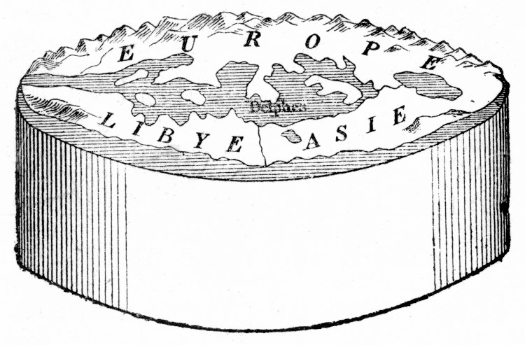
The cylindrical earth envisioned by Anaximander, early 6th cent. BCE
(Illustration by Léon Benett: C. Flammarion, Histoire du ciel, Paris, 1872, p. 289)

The myth’s underlying assumption is that, once upon a time, Eratosthenes estimated the circumference of the earth, but at some point, the knowledge that the earth is (very nearly) spherical somehow vanished. 19th century proponents of the myth often blame this on Catholics. And -- still according to the myth -- knowledge of the earth’s spherical shape was reinvented by Columbus in 1492.

To be clear, Europeans throughout the whole mediaeval period were well aware that we all live on a ball, not a pancake; and Columbus wasn’t out to prove the earth was round, he was trying to reach the East Indies, believing it was a journey of no more than 5000 km. (In fact it’s over 22,000 km, or would be if the Americas weren’t in the way; Columbus’ estimate of the east-west width of Eurasia was around 40% too high, and he accepted Ptolemy’s lower figure for the earth’s circumference, which was 28% too low). The idea that Columbus was fighting against entrenched flat-earthism was fabricated by Washington Irving in his History of the Life and Voyages of Christopher Columbus (1828; especially book 2, chapter 4). Irving believed that opposition to Columbus was based on ‘monkish bigotry and false learning’ (p. 10-11). Throughout the 19th century, anti-Catholic sentiment continued to fuel the Columbus myth: another key moment was Draper’s History of the conflict between religion and science (1875). Jeffrey Burton Russell’s book Inventing the flat earth: Columbus and modern historians (1991) tells a detailed story of how the Columbus myth came about.

To be fair, Washington Irving doesn’t deserve 100% of the blame for the myth -- maybe only 90%. Long before he came along, Copernicus and Kepler had both cherry-picked ancient flat-earthist testimony as a strawman for their own arguments.

For make no mistake: genuine flat-earthers did exist. Flat-earthism has probably never been anything other than a fringe belief, in any place and time where an awareness of the earth’s curvature has been known at all (with one possible exception, as we shall see below). But there has to have been a first time that the earth’s curvature was discovered; and even after discovery, dissenting voices have existed.

A scene from a debunking of flat-earthism. Modern flat-earthers have made screeds of ‘proofs’ of the earth’s flatness, but it is relatively uncommon to see a simulation like this of a ‘realistic’ flat earth, which pretty much instantly dispels the myth.
(source: YouTube)

Before Aristotle

In the Greek world, the turning-point between flat-earthism and round-earthism seems to be ca. 400 BCE. Prior to 400 BCE we have no evidence of anyone knowing or believing that the earth is round; after 400 BCE we see scarcely any more flat-earthers, and round-earthers pop up very quickly.

Early Greek myth didn’t have a single, coherent cosmology. The earliest texts that give us any idea at all of a cosmology are the mythical poems of Homer and Hesiod, in the first part of the 7th century BCE. Hesiod is vague and inconsistent, however: he doesn’t give a consistent portrayal of a well-defined universe. There’s more consistency in Homer, and Homer is much better known, which tends to give the impression that his version was standard; but that isn’t necessarily the case. In Homer, the cosmos comes broadly speaking in four layers, with ground-level at the middle.

A very approximate sketch of Homeric cosmology

Modern discussions sometimes portray the earth in Homeric cosmology as a disc. All we’re actually told is that it’s flat: that doesn’t automatically imply circular. The descriptions of Achilles’ and Heracles’ shields in the Iliad (ca. 670-650 BCE) and the Shield (ca. 600 BCE?) have them portraying a symbolic world surrounded by the mythical river Ocean running in a circle around the earth, but the shields were circular, so that’s not exactly surprising.

We get indications of a flat disc, or at least a circular object, in the 6th and 5th centuries BCE, with Anaximander (early 500s) and Herodotus (ca. 420s). Herodotus tells us that early map-makers were in the habit of making the Ocean circular (4.36.2): he condemns the practice, believing the shape of the Eurasian-African landmass to be more irregular. Anaximander is credited as the very first map-maker, and he envisaged the earth as a cylinder (see the illustration at the start of this post):
ὑπάρχειν δέ φησι τῶι μὲν σχήματι τὴν γῆν κυλινδροειδῆ, ἔχειν δὲ τοσοῦτον βάθος ὅσον ἂν εἴη τρίτον πρὸς τὸ πλάτος.
And he says that the earth is cylindrical in shape, and has a depth that is however much a third of its width is.
τὴν δὲ γῆν εἶναι μετέωρον ὑπὸ μηδενὸς κρατουμένην, μένουσαν δὲ διὰ τὴν ὁμοίαν πάντων ἀπόστασιν. τὸ δὲ σχῆμα αὐτῆς γυρόν, στρογγύλον, κίονι λίθωι παραπλήσιον: τῶν δὲ ἐπιπέδων ὧι μὲν ἐπιβεβήκαμεν, ὃ δὲ ἀντίθετον ὑπάρχει.
(And he says) that the earth is suspended in the sky, not held up by anything, staying in place because of its equal separation from all things. And that its shape is curved, round, similar to a stone column; and we walk on one of its faces, but it has an opposite (face).
(Anaximander frs. 12.A.10, A.11 ed. Diels-Kranz; similarly A.21, A.25, B.5)
(I have encountered some people who have been misled about Anaximander by Isaac Asimov: in an educational children’s book (1972), he misinterpreted the first of these fragments as suggesting that we live on the curved side of the cylinder. Actually the ‘stone column’ refers to column segments like these. The second fragment above, and Herodotus’ criticism of map-makers, both make it clear that Anaximander envisaged the cylinder as lying flat.)

It would be nice if we had more information about what early natural philosophers thought. Some testimony does exist, though. Two isolated, and very late, references attribute round-earthism to Pythagoras and Thales: Pythagoras, Diog. L. 8.48; Thales, Aëtius Plac. 3.10. But there’s essentially no doubt that these are both untrue. The Pythagoras passage also ascribes round-earthism to Hesiod and Anaximander, and we know both of these are false; and the source, Diogenes Laertius, isn’t very reliable as a rule. And in Thales’ case, a much earlier source tells us that he taught the earth floats in water like a piece of wood (Aristotle On the sky 294a28-b1 = fr. 11.A.14 ed. Diels-Kranz; see further Couprie 2011: 63-7).

Besides, in 6th-5th-century BCE thinkers we see an overwhelming consensus that the earth was flat. If Pythagoras or Thales were round-earthers, it would have been a very exceptional thing, so we’d expect a well-informed writer like Aristotle to highlight it. Here’s a selection of what pre-Socratic thinkers did believe about the shape of the world (fragment numbers follow the standard edition of Diels and Kranz 1952):
  • Anaximenes (500s BCE): the earth is πλατεῖαν μάλα ‘very flat’ (fr. 13.A.6; also A.7§4, which adds that sun, moon, and other astronomical bodies are all flat; also A.20), and suspended in space by air pressure underneath (A.20).
  • Anaxagoras (ca. 460-430): the earth is πλατείας ‘flat’ (frs. 59.A.1§8, A.42§3, A.47, A.87); as in Anaximenes, it is suspended by air pressure (13.A.20).
  • Archelaus (ca. 450): the earth is not perfectly flat but κύκλῳ μὲν οὖσαν ὑψηλήν, μέσον δὲ κοίλην ‘high in a ring, and concave in the middle’; he uses this to explain different times of sunrise and sunset in different parts of the world (fr. 60.A.4§4).
  • Empedocles (mid-400s): the earth is κυκλοτερής ‘circular’ (i.e. disc-shaped; fr. 31.A.56; also A.50, which discusses the earth’s horizontal expanse).
  • Leucippus (400s): the earth is τυμπανῶδες or τυμπανοειδῆ ‘drum-shaped’ (frs. 67.A.1§30, A.26), but tilts downwards to the south, resulting in colder climates in the north (A.1§33).
  • Diogenes of Apollonia (ca. 440-430): the earth is στρογγύλην, ἠρεισμένην ἐν τῷ μέσῳ ‘circular, supported in the middle’ (fr. 64.A.1; στρογγύλος can also mean ‘spherical’, but in context it must refer to a flat circle).
  • Democritus (second half of 400s): as in Archelaus, the earth is δισκοειδῆ μὲν τῷ πλάτει, κοίλην δὲ τῷ μέσῳ ’disc-shaped in its surface, but concave in the middle’ (fr. 68.A.94); it is not a perfect disc, however, but προμήκης ... ἡμιόλιον το μῆκος τοῦ πλάτους ἔχουσα ‘elongated, oblong along the length of its surface’ (B.15§2); as in Leucippus, the earth tilts downwards to the south (A.1§33); as in Anaximenes and Anaxagoras, it is suspended in space by air pressure underneath (13.A.20).
Early Greek cosmology could get pretty wild. It’s just as well we don’t have to go into the cosmology that we see in Parmenides and in Plato’s Timaeus just now, or we’d really go bananas. However, in the midst of all this speculation some useful ideas did pop up. Notably Anaximander and Archelaus: though they were flat-earthers, they did lay an important piece of conceptual groundwork for the principle of round-earth gravity, in which all things fall towards the centre of the earth. As we saw above, Anaximander’s earth was stable in the centre of the cosmos because of its ‘equal separation from all things’; Archelaus’ earth was at the centre because all things gravitate towards the centre (fr. 60.A.4§2). In both cases the earth requires no physical supports. Both of these are counter-arguments to the Pythagorean picture of the cosmos, which has the earth attached to one of the celestial spheres moving around the central fire. If Anaximander’s and Archelaus’ ideas of the suspended earth hadn’t existed, it might have been a lot harder for round-earthism to take off.

For take off it did. We don’t know who came up with the idea first. Dirk Couprie (2011: 169) suspects Oenopides (mid-400s BCE), who is credited as the discoverer of the ecliptic. The ecliptic is the plane of the earth’s orbit, at an angle to the equator, so one might wonder if Oenopides also realised that it implied a spherical earth. We can’t be sure.

Whoever it was, the earth’s sphericity was well known enough by the early 300s BCE that Plato could take knowledge of it for granted (Phaedo 108e-109a). By the mid-to-late 300s we find Aristotle (On the sky 296b-297b) explicitly discussing empirical evidence for the spherical shape of the earth; how gravity impels all objects towards the centre of the earth; and an (inaccurate) estimate for its circumference. Perhaps most famously, in the mid-200s Eratosthenes comes up with the first roughly accurate and empirical determination of the earth’s circumference.

Aristotle’s evidence for the earth’s sphericity
(source: PracticalPhysics.org, adapted)

From Aristotle onwards the earth’s shape was common knowledge.

Aristotle to the 4th century CE

Flat-earthers didn’t vanish altogether -- Epicurus, who lived into the 200s BCE, was a flat-earther, and plenty of later Epicureans subscribed to his teachings -- but they were a minority. Roman thinkers like Cicero and Pliny spend time discussing the spherical earth and Aristotelean gravity; the round earth is fundamental to the work of astronomers like Hipparchus; and its shape was considered very carefully in Eratosthenes’ Geography, Strabo’s Geography (2.5.1-11), and Ptolemy’s Geographica.

All three of these writers discuss the problem of how to project a spherical surface onto a flat map. Strabo, the least technical of the three, is relatively dismissive: as far as he’s concerned, make the map big enough and the inaccuracies won’t matter (2.5.10). But for Eratosthenes and Ptolemy it was a serious problem. (Even today people still argue over which flat projection is best.) Ptolemy devotes most of the first book of the Geographica to an extended theoretical discussion of the ‘right’ projection; the rest of his atlas is a catalogue of place-names and topographical details, using a very modern-looking system of latitude and longitude. For Eratosthenes and Strabo things were somewhat simpler, in that they only needed to worry about a smaller portion of the earth as known to them. Eratosthenes regarded the known world, or oikoumenē, as a quadrilateral on the curved surface of the earth (Eratosthenes Geography fr 30 ed. Roller = Strabo 2.5.5-6; similarly Erat. frs. 31, 32, 33, 34). According to Strabo, the resulting non-Euclidean shape was called a sphondylos (‘whorl’), and the land within this region was the shape of a chlamys (‘cloak’) draped over the sphere.

Eratosthenes’ sphondylos ‘whorl’: the quadrilateral of the known world (oikoumenē). The edges of the quadrilateral are lines of latitude and longitude.

Incidentally, Ptolemy is the person responsible for the modern convention of putting north at the top of a map. This practice isn’t self-evident, and it wasn’t a universal standard in Ptolemy’s time: Cleomedes (somewhere between 2nd and 4th century CE) arranges west at the top, and north to the right. Ptolemy, in the prologue to Geographica book 2, observes that he has the most detailed geographical data for the north-west of the Eurasian landmass, so he decides to put that material in the first place that people will look -- at the top left of his map. In the Renaissance, 15th century western cartographers revived Ptolemy’s convention, so that it has become the modern standard. (If Greek had been written right-to-left in Ptolemy’s time, our maps today would have west at the top ...)

Crates of Mallos, a Greek scholar living in Rome in the 2nd century BCE, is sometimes credited as creating the first ever globe map. He certainly discussed the nature of the globe, as reported by Strabo 2.5.10: but Strabo doesn’t refer to a physical globe, only to a Kratēteion, ‘Crates’ (interpretation)’. Anything else would be very surprising anyway: Crates wasn’t a natural philosopher, but a very bookish literary critic. Strabo was probably thinking of Crates writing about the geography in the Homeric Odyssey, and Crates’ bizarre argument that Homer must have known the earth was spherical (Crates frs. 37 and 54 ed. Broggiato).

Even poets took the round earth for granted. Here’s a passage from the opening of Ovid’s epic the Metamorphoses, describing the primordial state of the universe (Met. 1.5-13) --
Before the sea and earth, and the sky which touches all things,
the form of nature was one throughout the entire universe:
they called it Chaos. ...
... and [as yet] the earth did not hang in the air flowing around it,
poised by its own weights ...
‘Poised by its own weights’ refers to the Aristotelean teaching on gravity: all bodies are attracted to the centre of the earth, so the earth’s weight is balanced around the centre.

Late antiquity and the mediaeval period

In the history of the Latin west we know of vanishingly few flat-earthers prior to the emergence of modern flat-earthism in the Victorian period. The only one who is at all well known is Lactantius, a rhetorician and Christian apologist of the late 200s/early 300s CE. His mockery of round-earthism (Divine institutes 3.24) is routinely cited as exemplary of the backwardness of Christian thought. It was Copernicus who began the tradition of targetting him -- though unlike later writers, Copernicus doesn’t pick on Lactantius’ religion (De revolutionibus ivb).

But Lactantius is almost unique. Nearly all other figures in the Latin world who had anything to say on the subject -- Augustine, Macrobius, Boethius, Isidore, Bede, Thomas Aquinas, Dante (all Christians, you’ll notice) -- were round-earthers. Augustine, City of God 16.9, is sometimes cited as belonging to the flat-earth camp, but the only doubt he expresses is over the assumption that there must necessarily be a landmass at the antipodes, or that if there is one that it is necessarily inhabited. (By luck he was quite right: the point on the earth’s surface opposite his hometown, Hippo in modern Algeria, is underwater in the southern Pacific, over 1100 km east of Auckland, New Zealand -- and indeed there were no humans in New Zealand in Augustine’s lifetime.)

Bede is an especially striking exemplar of western learning on the subject: his treatise On the measuring of time is precisely about the astronomical basis for the calendar, and he talks at length about the spatial relationships between the sun, moon, stars, and the spherical earth: for example (De ratione temporum §32),
causa autem inaequalitatis eorundem dierum terrae rotunditas est: neque enim frustra et in scripturae divinae, et in communium literarum paginis orbis terrae vocatur. est enim re vera orbis idem in medio totius mundi positus, non in latitudinis solum gyro, quasi instar scuti rotundus, sed instar potius pilae undique versum aequali rotunditate persimilis: ...
The cause of the inequality of days is the roundness of the earth. It is not for nothing that it is called ‘the orb of the earth’ in the pages of both divine scripture and general literature. For in fact the orb is positioned in the centre of the entire cosmos, not just in a wide circle in the likeness of a shield, but rather in the likeness of a ball which is identical in equal roundness on every side ...
Notice that this passage doesn’t just show an awareness of the earth’s shape, but also of the angle of the ecliptic and its importance to the seasons. See also Bede’s De natura rerum, at sections §46 (‘We refer to the orb of the earth not because its shape is that of a perfect orb, given the great difference between mountains and plains, but because ... [its overall shape] makes a figure of a perfect orb’) and §5-§10.

The Greek-speaking world is much less tidy. There, we do find a cluster of genuine flat-earthers, and a pronounced absence of round-earthers -- to the point where it looks very much as if some parts of the early Byzantine world were, after all, predominantly flat-earthers.

In the decades before and after emperor Theodosius I, who waged a campaign of radical dehellenisation in the 380s and 390s CE, we find many figures espousing flat-earthism on the basis of biblical passages -- Ephrem of Syria, John Chrysostom, Diodorus of Tarsus, Severian of Gabala, and Theodore of Mopsuestia, and perhaps several others who are less clear-cut. Most of these figures came from Syria and learned from each other: John Chrysostom studied under Diodorus, Severian knew Ephrem’s work and had a troubled relationship with both Chrysostom and Diodorus. Johannes Zellinger has written of them as representing a ‘Syrian-Antiochene school’ of biblical literalism (Zellinger 1916: 75). Was flat-earthism confined to Syria, though? John Chrysostom, Diodorus, and Severian taught and preached in Constantinople too.

Full references:
Later Byzantines were less concerned with literalism. John Philoponus (6th cent.) admits, in his On the creation of the world, that it’s impossible to write about the Genesis creation story in physical or astronomical terms without contradiction (De opificio mundi 1.2). And Photius, the 9th century scholar and patriarch who is our source for Diodorus of Tarsus, is doubtful about Diodorus’ theories (Myr. 210b.4: ‘there is no compelling proof of this’).

But flat-earthism lived on beyond the 4th and 5th centuries. The most notorious piece of Byzantine flat-earthism comes from Philoponus’ time. In the 6th century we find a work called Christian topography by Cosmas, an Alexandrian monk (nicknamed Indikopleustes, ‘sailor to India’, because he embarked on a voyage there once, though he didn’t reach his destination). Cosmas again adopts a radically literalist reading of some biblical passages, but goes into far more detail than any of the Syrians. Topography book 2 (text; translation) gives a description of the shape and size of the world that is totally uncontaminated by anything non-biblical. Led by Genesis 1, Cosmas takes Hebrews 9:1-14 to be saying that the universe has the same form as the tabernacle described in Exodus 25-26, and that the earth has the same form as the ark of the covenant -- that is to say: flat, with four walls, and a lid on top. (Yes, really. Here are a couple more discussions of Cosmas that go into more detail: 1, 2.)

Cosmas’ conception of the earthly world (source: Zellinger 1916: 81)

So even though none of the details invented by Washington Irving are real, the flat earth myth isn’t all imaginary. There were flat-earthers in antiquity and in the early mediaeval period. And some flat-earthers did take their beliefs from literalist interpretations of biblical passages. But, once round-earthism initially took off, they were never a majority -- with the possible exception of 4th-5th century Syria (and Constantinople?).

‘But yeah but yeah but that was only educated people. Uneducated people still believed the earth was flat, right?’

That kind of anti-scepticism -- the insistence that people in times past must have been stupid -- is worthy of the History Channel. Ultimately what we have to go on is what the evidence tells us. And the evidence suggests that flat-earthism was a tightly confined phenomenon, at least until the Victorian era. We have essentially no evidence of flat-earthism in the Latin west; and the evidence that we do have from the Greek east comes to us from only one period of religious extremism.

References

  • Asimov, I. 1972. How did we find out the earth is round? New York: Walker & Co.
  • Broggiato, M. 2001. Cratete di Mallo. I frammenti. La Spezia: Agorà Edizioni.
  • Couprie, D. 2011. Heaven and earth in ancient Greek cosmology: from Thales to Heraclides Ponticus. New York: Springer.
  • Diels, H.; Kranz, W. 1952. Die Fragmente der Vorsokratiker, 3 vols., 6th ed. Berlin: Weidmann.
  • Roller, D. W. 2010. Eratosthenes’ Geography. Princeton: Princeton University Press.
  • Zellinger, J. 1916. Die Genesishomilien des Bischofs Severian von Gabala. Münster: Aschendorffsche Buchhandlung.

30 November 2015

Eratosthenes and the well

Eratosthenes is one of the most famous individuals of the Greco-Roman world -- and justly so: he was a leading expert in cartography, philology, mythography, ethnography, geometry, and astronomy. In an age of nepotism, his raw talent and hard work got him headhunted by Ptolemy III while he was still living in Athens.

Nowadays, he is most famous for making a reasonably accurate calculation of the circumference of the earth, using 3rd century BCE data and methods. This was a celebrated feat in his own time too. The island of Elephantine, at Syene (modern Aswan), had a new hieroglyphic symbol for its name created, apparently in honour of his calculation, in the form of a plumb bob and try square.
Hieroglyph
for Elephantine
(one of many variants)

No myths so far: this story is all true. By calculating the relative angle of elevation of the midday sun in three cities on the same meridian and at the same season -- Alexandria, Syene (modern Aswan), and Meroë (the chief city of what the Greeks called Aithiopia; modern Bagrawiya, Sudan) -- with figures for the distances between these cities, and with the assumption that the earth's curvature was spherical -- he came up with a figure variously reported as either 250,000 or 252,000 stadia.

In terms of angular precision, the calculation was very exact. In terms of absolute distances, not so much. Eratosthenes' own writings on the subject do not survive. It's most likely that he calculated 250,000 stadia, but that the figure got "rounded" to 252,000 so as to give a tidy figure of 700 stadia per degree of the earth's circumference (360° × 700 = 252,000). More importantly, Ptolemaic methods for surveying long distances were very inexact -- not nearly as good as Roman measures, for example -- and, to boot, there were many variants of the stadion ranging from ca. 157 metres to ca. 262 metres. The problem of Eratosthenes' units is hair-pullingly complicated. (Maybe we'll revisit the subject one day. But then again, maybe not: it really is a messy topic.)

But how he calculated the earth's circumference -- that's where the myths come in. Here's an extract from an especially popular and influential account:
One day, while reading a papyrus book in the library, he came upon a curious account. Far to the south, he read, at the frontier outpost of Syene, something notable could be seen on the longest day of the year. On June 21st, the shadows of a temple column or a vertical stick would grow shorter as noon approached. And as the hours crept towards midday, the sun's rays would slither down the sides of a deep well, which on other days would remain in shadow. And then precisely at noon columns would cast no shadows, and the sun would shine directly down into the water of the well. At that moment the sun was exactly overhead. It was an observation that someone else might easily have ignored -- sticks, shadows, reflections in wells, the position of the sun: simple everyday matters. Of what possible importance might they be?
-- Carl Sagan, Cosmos (1980; episode 1, "The shores of the cosmic ocean")
NOT how Eratosthenes calculated the earth's circumference
The story of the well is repeated in a lesson at the Khan Academy, in an even more colourful (and fictional) account in Julia Diggins' 1965 book String, Straightedge, and Shadow, and in many more places.

And it is mostly false. There was a well like this at Syene: but it certainly had nothing to do with Eratosthenes, and nothing at all to do with his calculation.

Here's Pliny the Elder's account of the well (Natural History 2.183 [§75]):
Similarly they say that in the town of Syene, 5000 stadia south of Alexandria, no shadow is cast at noon on the solstice. A well was made to test this, and it was entirely illuminated. This showed that the sun was directly overhead at that time. Onesicritus states that the same thing happens at that season in India south of the river Hyphasis [i.e. the modern Beas].
(The source Pliny was using is vague: "south of the Hyphasis" sounds like it should indicate Punjab, but the tropic runs considerably south of Punjab. It does run close to Pataliputra, though, further to the south-east, which was the capital of the Maurya Empire until the early 2nd century BCE: that is probably what Pliny's Hellenistic source was talking about.) Strabo also describes the well (17.1.48), and his phrasing tends to suggest that it was moderately famous, though unlike Pliny he doesn't say that its unique feature was the very reason it was built.

No ancient source, at all, anywhere, connects this well to Eratosthenes. In the surrounding context of these passages, however, both Pliny and Strabo do mention the actual method that Ptolemaic surveyors used for measuring latitude: they used an instrument called the gnomon (Pliny NH 2.182; Strabo 17.1.48).

Gnomons were originally for determining the date of the solstice. This practice goes back many thousands of years, in many different civilisations. Meton used a gnomon in Athens in 432 BCE for this purpose; the Shang people in ancient China were using them to measure solstices in the 13th century BCE. In Egypt, one of the reliefs in the jubilee chapel of Senusret I depicts a 9-metre-high gnomon in connection with the festival of Min in the 20th century BCE.

In its simplest form, the gnomon was a vertical rod that cast a shadow. Measuring the ratio between the shadow and the length of the rod would constitute a gnomon reading. Old Egyptian gnomons typically had a bifurcated tip to make the shadow more defined (as in the Senusret relief). The Egyptians could use hand-held ones to mark the passage of time at night. Travellers in the Greco-Roman world had portable gnomons or sundials, in the form of a round vessel with a stylus embedded in the centre and markings on the sides: this set-up was called a skaphion (Greek) or umbilicus (Latin). The Egyptians were well aware that near the tropic it was difficult to measure the solstice with a vertical gnomon, because the shadows are so short at midsummer, and so they adopted the practice of tilting the gnomon to the north and supporting it with struts. (Further reading, for those with JSTOR access.) In later gnomons, plumb bobs were used to ensure it was exactly vertical: to judge from the hieroglyphic for Elephantine mentioned above, it looks like this was the case with the Ptolemaic gnomon. (And incidentally, remember that the symbol for Elephantine included a try square? It so happens that gnomon was also the Greek word for a try square.)

Ancient travellers regularly took gnomon readings as a way of recording their latitude. Pliny, just before the passage quoted above, tells us
Portable timepieces are not used the same way everywhere, because the sun's shadows change every 300 stadia, or at most 500 stadia [i.e. about 0.5° latitude]. So in Egypt at the equinox the shadow is only a little more than half the length of the umbilicus -- what they call a gnomon. In the city of Rome the shadow is 8/9 the length of the gnomon at the same season; in the town of Ancona it is 1/35 longer (i.e. 8/9 + 1/35, or 0.917); and in the region of Italy called Venetia the shadow is the same length.
Vitruvius gives another list of equinoctial gnomon readings in various cities. Ptolemy has an extended account of gnomons and latitude in book 2 of his Almagest. And Martianus Capella indicates that Eratosthenes' measurement was based on gnomon readings taken at the equinox (De nuptiis 6.597).

The practice of taking gnomon readings as a geographical measurement goes back at least to Pytheas of Massalia, a famed traveller of the early mid-4th century BCE. According to Martianus Capella (De nuptiis 6.595), Pytheas took gnomon readings all the way from southern France to "Thoule" (either Iceland, or one of the island groups in the North Sea, or perhaps Scandinavia). Also before Eratosthenes' time, Philon, a surveyor for Ptolemy II, reported gnomon readings at Meroë in his book the Aithiopika or Voyage to Aithiopia. The book itself does not survive, but this report does:
Philon discusses the latitude (κλῖμα) of Meroë in the Voyage to Aithiopia that he wrote. He says the sun is directly overhead 45 days before the summer solstice, and he reports his readings of the ratio between the gnomon and its shadow at the solstices and equinoxes. Eratosthenes agrees very closely (συμφωνεῖν ἔγγιστα) with Philon.
Philon, New Jacoby 670 F 2 (=Strabo 2.1.20)
So, to recapitulate:
  • Eratosthenes didn't use a well to measure anything: the instrument of choice was the gnomon.
  • Taking latitude readings from a gnomon was standard practice for Ptolemaic surveyors decades before Eratosthenes came along.
  • The summer solstice barely came into it; gnomon readings were taken year-round, but it looks like equinoctial readings were the basis of Eratosthenes' calculation.
  • Eratosthenes didn't take the readings himself: he probably used Philon's published work as the basis of his calculation.
The well at Syene was just a striking, large-scale visualisation of the Tropic of Cancer. Pliny's wording suggests it may not even been built until after Eratosthenes' calculation anyway. And native Egyptians had known for centuries that Syene was on the Tropic of Cancer. (In fact Syene was slightly north of the tropic: it's at 24.09° N, and the tropic was at 23.72° N in Eratosthenes' time. The plane of the ecliptic shifts slightly over the millennia: currently it's at 23.44°.)